News
UC San Diego Mountaintop Cameras Provide Insight to Scarcely Understood Wildfire Phenomenon
Published October 28, 2024
Kimberly Mann Bruch, SDSC Communications
For more than two decades, the High Performance Wireless Research and Education Network (HPWREN) has been providing high-speed networking capabilities to hard-to-reach areas within southern California. Based at UC San Diego as a collaboration between an array of researchers at the School of Computing, Information and Data Sciences’ San Diego Supercomputer Center (SDSC), Scripps Institution of Oceanography and the Qualcomm Institute, the HPWREN team deploys high-resolution cameras for real-time situational awareness. These cameras are located on isolated mountain tops and often used by first responders in emergency situations such as wildfires like the recent Airport Fire in southern California’s Riverside County.
“The current HPWREN state-of-the-art mountaintop camera systems feature fixed field-of-view cameras pointing in the cardinal directions, utilizing both color and monochrome sensors,” said Frank Vernon, HPWREN principal investigator and a researcher in the Institute of Geophysics and Planetary Physics at Scripps Institution of Oceanography.
The technology helps detect certain emergencies as they happen in the surrounding environment – such as detecting a fire ignition location. Hans-Werner Braun, a research scientist at SDSC and co-founder of HPWREN, said that the recent Riverside County Airport Fire footage was utilized by colleagues at the Bushfire Research Group at the University of New South Wales – or UNSW – in Canberra, Australia.
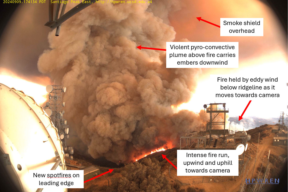
Specifically, UNSW Adjunct Professor Rick McRae has been communicating with Braun on analyzing a series of HPWREN-based images that were captured that depict the vorticity-driven lateral spread (VLS) during the Airport Fire. McRae said that because VLS often spreads in two directions, real-time data such as that transmitted thanks to HPWREN real-time cameras could be used as a model for researchers in Australia.
“On the 18th of January in 2003 a massive firestorm swept into the western suburbs of Canberra, where I was the planning officer and oversaw the wildfires, which destroyed more than 500 homes,” McRae said. “In a city where no homes were lost to bushfires in the preceding 80 years, this was a major shock and all due to VLS.”
McRae said that since then, he has continuously explored an array of technology that might help better mitigate these types of situations, but until he saw the HPWREN images from the Airport Fire, he had not seen the clear depiction of VLS. The primary cause of major fires, VLS requires sturdy fire-resistant cameras and the HPWREN cameras atop Santiago Peak during the Airport Peak provided just that.

An HPWREN image of the VLS approaching the Santiago Peak cameras. This form of fire behaviour is very dangerous because the fire is spreading in two directions at once, and it is spread by dense spotting, which can easily cross containment lines and can rapidly degrade situational awareness for fire crews. Credit: HPWREN
“We now have good videos of one VLS event – thanks to HPWREN,” McRae said. “If we get more in the future, we can improve our theories and our fire ground safety – on the other hand, I hope to never hear about a VLS event again, because that often means someone had a bad day.”
“In most cases, HPWREN cameras are queried for a new image once per minute all year long, although in some cases the interval has been shortened to an image every ten seconds,” said Braun. “The cameras can provide images at a much higher rate, for example during a fire, which then results in a requirement for more storage and bandwidth.”
SDSC Director Frank Würthwein said that the goal of the center is to support the full lifecycle from fundamental research to impactful applications deployed to address societal challenges. “We call this process ‘transitional data science’,” he explained. “And it is extremely gratifying to see that the images taken by HPWREN cameras advance our scientific understanding of fires, in addition to being useful for operational firefighting.”
“HPWREN has been a steady data source for nearly two decades, enabling our work to develop wildland fire applications with fire science and management communities,” further explained WIFIRE Lab Founder and Director Ilkay Altintas, who is also the chief data officer at SDSC. “This story highlights the importance of open data to enable new science. We are really excited about the possible collaborations with researchers like McRae at the UNSW as there is so little data out there that clearly depicts VLS.”
The WIFIRE Lab is a part of the Cyberinfrastructure and Convergence Research (CICORE) Division at SDSC and provides expertise in data science, AI and advanced computing to partnerships and projects focused on achieving scientific and societal impact. CICORE has a passion for solving complex, data intensive problems and a commitment to developing the next generation of technological leaders. The CICORE Division is known for its broad expertise in cyberinfrastructure; domain-specific expertise in AI-enabled science; successful partnerships with policymakers, practitioners and industry; and experiential education initiatives.

